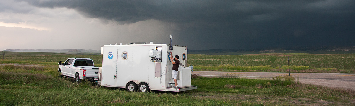
CLAMPS (or the Collaborative Lower Atmospheric Mobile Profiling System) was originally envisioned as a deployable boundary layer profiling system that is able to measure profiles of temperature, water vapor, and wind in the lowest several kilometers of the atmosphere at high temporal resolution using a particular combination of instruments. This instrument suite, and more specifically, the dataset derived from these observations, allows the users to identify and quantify significant changes in the atmospheric thermodynamic or dynamic structure. The real-time and continuous observation of these atmospheric properties is useful for characterizing the pre-convection environment for research on convective systems, mesoscale dynamic studies, research on nowcasting and forecasting local weather, technique development for remote sensing, urban meteorology, air quality and chemical weather analyses, research on boundary layer evolution, and other applications. In other words, the system allows for a unique breadth of research topics and applications. At the time of CLAMPS’s inception, no comparable capability existed within the university community or NOAA/OAR, and the CLAMPS system was the first to combine two thermodynamic profiling capabilities. While the three remote sensors that make up the CLAMPS mobile facility have a significant history, integration of the three together is what makes CLAMPS unique and powerful. The CLAMPS platform is made up of three main instruments: a Doppler lidar, a microwave radiometer (MWR), and an atmospheric emitted radiance interferometer (AERI). In addition to these three, CLAMPS also supports surface meteorological observations and a balloon radiosonde system.
CLAMPS is a collaborative effort between the NOAA National Severe Storms Laboratory (NSSL) and the University of Oklahoma (OU) School of Meteorology (SoM). Two CLAMPS facilities are operated by the collaborative team. CLAMPS-1 was funded by the NSF, NSSL, and OU, and was constructed in 2015. CLAMPS-2 was built in early 2016 with funding from NSSL. The CLAMPS facilities are trailer-based systems with their own generators and thus are easily transported to different locations; they can also be operated from shore power.
These references provide examples of CLAMPS data applications in published science and/or information about CLAMPS instrumentation and retreivals.
41. LaFleur, A. T., R. L. Tanamachi, D. T. Dawson, and D. D. Turner, 2023: Factors Affecting The Rapid Recovery Of Cape On 31 March 2016 During Vortex-Southeast.
Monthly Weather Review,
1,
https://doi.org/10.1175/MWR-D-22-0051.1.
40. Duncan Jr., J. B., and Coauthors, 2022: Evaluating convective planetary boundary layer height estimations resolved by both active and passive remote sensing instruments during the CHEESEHEAD19 field campaign.
Atmospheric Measurement Techniques,
15, 2479–2502,
https://doi.org/10.5194/amt-15-2479-2022.
39. Jensen, A. A., and Coauthors, 2022: Assimilation of a Coordinated Fleet of Uncrewed Aircraft System Observations in Complex Terrain: Observing System Experiments.
Monthly Weather Review,
150, 2737–2763,
https://doi.org/10.1175/MWR-D-22-0090.1.
38. Späth, F., A. Behrendt, W. A. Brewer, D. Lange, C. Senff, D. D. Turner, T. J. Wagner, and V. Wulfmeyer, 2022: Simultaneous Observations of Surface Layer Profiles of Humidity, Temperature, and Wind Using Scanning Lidar Instruments.
Journal of Geophysical Research: Atmospheres,
127, e2021JD035697,
https://doi.org/10.1029/2021JD035697.
37. Bell, T. M., P. M. Klein, J. K. Lundquist, and S. Waugh, 2021: Remote-sensing and radiosonde datasets collected in the San Luis Valley during the LAPSE-RATE campaign.
Earth System Science Data,
13, 1041–1051,
https://doi.org/10.5194/essd-13-1041-2021.
36. Butterworth, B. J., and Coauthors, 2021: Connecting Land–Atmosphere Interactions to Surface Heterogeneity in CHEESEHEAD19.
Bulletin of the American Meteorological Society,
102, E421–E445,
https://doi.org/10.1175/BAMS-D-19-0346.1.
35. Jensen, A. A., and Coauthors, 2021: Assimilation of a Coordinated Fleet of Uncrewed Aircraft System Observations in Complex Terrain: EnKF System Design and Preliminary Assessment.
Monthly Weather Review,
149, 1459–1480,
https://doi.org/10.1175/MWR-D-20-0359.1.
34. Lin, G., C. Grasmick, B. Geerts, Z. Wang, and M. Deng, 2021: Convection Initiation and Bore Formation Following the Collision of Mesoscale Boundaries over a Developing Stable Boundary Layer: A Case Study from PECAN.
Monthly Weather Review,
149, 2351–2367,
https://doi.org/10.1175/MWR-D-20-0282.1.
33. Sanchez Gomez, M., J. K. Lundquist, P. M. Klein, and T. M. Bell, 2021: Turbulence dissipation rate estimated from lidar observations during the LAPSE-RATE field campaign.
Earth System Science Data,
13, 3539–3549,
https://doi.org/10.5194/essd-13-3539-2021.
32. Smith, E. N., and Coauthors, 2021: Evaluation and Applications of Multi-Instrument Boundary-Layer Thermodynamic Retrievals.
Boundary-Layer Meteorol,
181, 95–123,
https://doi.org/10.1007/s10546-021-00640-2.
31. Wade, A. R., and M. D. Parker, 2021: Dynamics of Simulated High-Shear, Low-CAPE Supercells.
Journal of the Atmospheric Sciences,
78, 1389–1410,
https://doi.org/10.1175/JAS-D-20-0117.1.
30. Bell, T. M., B. R. Greene, P. M. Klein, M. Carney, and P. B. Chilson, 2020a: Confronting the boundary layer data gap: evaluating new and existing methodologies of probing the lower atmosphere.
Atmospheric Measurement Techniques,
13, 3855–3872,
https://doi.org/10.5194/amt-13-3855-2020.
29. ——, P. Klein, N. Wildmann, and R. Menke, 2020b: Analysis of flow in complex terrain using multi-Doppler lidar retrievals.
Atmospheric Measurement Techniques,
13, 1357–1371,
https://doi.org/10.5194/amt-13-1357-2020.
28. Boer, G. de, and Coauthors, 2020: Development of Community, Capabilities, and Understanding through Unmanned Aircraft-Based Atmospheric Research: The LAPSE-RATE Campaign.
Bulletin of the American Meteorological Society,
101, E684–E699,
https://doi.org/10.1175/BAMS-D-19-0050.1.
27. Chipilski, H. G., X. Wang, and D. B. Parsons, 2020: Impact of Assimilating PECAN Profilers on the Prediction of Bore-Driven Nocturnal Convection: A Multiscale Forecast Evaluation for the 6 July 2015 Case Study.
Monthly Weather Review,
148, 1147–1175,
https://doi.org/10.1175/MWR-D-19-0171.1.
26. Degelia, S. K., X. Wang, D. J. Stensrud, and D. D. Turner, 2020: Systematic Evaluation of the Impact of Assimilating a Network of Ground-Based Remote Sensing Profilers for Forecasts of Nocturnal Convection Initiation during PECAN.
Monthly Weather Review,
148, 4703–4728,
https://doi.org/10.1175/MWR-D-20-0118.1.
25. Lyza, A. W., T. A. Murphy, B. T. Goudeau, P. T. Pangle, K. R. Knupp, and R. A. Wade, 2020: Observed Near-Storm Environment Variations across the Southern Cumberland Plateau System in Northeastern Alabama.
Monthly Weather Review,
148, 1465–1482,
https://doi.org/10.1175/MWR-D-19-0190.1.
24. Barbieri, L., and Coauthors, 2019: Intercomparison of Small Unmanned Aircraft System (sUAS) Measurements for Atmospheric Science during the LAPSE-RATE Campaign.
Sensors,
19, 2179,
https://doi.org/10.3390/s19092179.
23. Chilson, P. B., and Coauthors, 2019: Moving towards a Network of Autonomous UAS Atmospheric Profiling Stations for Observations in the Earth’s Lower Atmosphere: The 3D Mesonet Concept.
Sensors,
19, 2720,
https://doi.org/10.3390/s19122720.
22. Coniglio, M. C., G. S. Romine, D. D. Turner, and R. D. Torn, 2019: Impacts of Targeted AERI and Doppler Lidar Wind Retrievals on Short-Term Forecasts of the Initiation and Early Evolution of Thunderstorms.
Monthly Weather Review,
147, 1149–1170,
https://doi.org/10.1175/MWR-D-18-0351.1.
21. Degelia, S. K., X. Wang, and D. J. Stensrud, 2019: An Evaluation of the Impact of Assimilating AERI Retrievals, Kinematic Profilers, Rawinsondes, and Surface Observations on a Forecast of a Nocturnal Convection Initiation Event during the PECAN Field Campaign.
Monthly Weather Review,
147, 2739–2764,
https://doi.org/10.1175/MWR-D-18-0423.1.
20. Fernando, H. J. S., and Coauthors, 2019: The perdigão: Peering into microscale details of mountain winds.
Bulletin of the American Meteorological Society,
100, 799–819,
https://doi.org/10.1175/BAMS-D-17-0227.1.
19. Flournoy, M. D., and M. C. Coniglio, 2019: Origins of Vorticity in a Simulated Tornadic Mesovortex Observed during PECAN on 6 July 2015.
Monthly Weather Review,
147, 107–134,
https://doi.org/10.1175/MWR-D-18-0221.1.
18. Hu, J., N. Yussouf, D. D. Turner, T. A. Jones, and X. Wang, 2019: Impact of Ground-Based Remote Sensing Boundary Layer Observations on Short-Term Probabilistic Forecasts of a Tornadic Supercell Event.
Weather and Forecasting,
34, 1453–1476,
https://doi.org/10.1175/WAF-D-18-0200.1.
17. Johnson, A., and X. Wang, 2019: Multicase Assessment of the Impacts of Horizontal and Vertical Grid Spacing, and Turbulence Closure Model, on Subkilometer-Scale Simulations of Atmospheric Bores during PECAN.
Monthly Weather Review,
147, 1533–1555,
https://doi.org/10.1175/MWR-D-18-0322.1.
16. Lin, G., B. Geerts, Z. Wang, C. Grasmick, X. Jing, and J. Yang, 2019: Interactions between a Nocturnal MCS and the Stable Boundary Layer as Observed by an Airborne Compact Raman Lidar during PECAN.
Monthly Weather Review,
147, 3169–3189,
https://doi.org/10.1175/MWR-D-18-0388.1.
15. Loveless, D. M., T. J. Wagner, D. D. Turner, S. A. Ackerman, and W. F. Feltz, 2019: A Composite Perspective on Bore Passages during the PECAN Campaign.
Monthly Weather Review,
147, 1395–1413,
https://doi.org/10.1175/MWR-D-18-0291.1.
14. Markowski, P. M., N. T. Lis, D. D. Turner, T. R. Lee, and M. S. Buban, 2019: Observations of Near-Surface Vertical Wind Profiles and Vertical Momentum Fluxes from VORTEX-SE 2017: Comparisons to Monin–Obukhov Similarity Theory.
Monthly Weather Review,
147, 3811–3824,
https://doi.org/10.1175/MWR-D-19-0091.1.
13. Smith, E. N., J. G. Gebauer, P. M. Klein, E. Fedorovich, and J. A. Gibbs, 2019: The Great Plains Low-Level Jet during PECAN: Observed and Simulated Characteristics.
Monthly Weather Review,
147, 1845–1869,
https://doi.org/10.1175/MWR-D-18-0293.1.
12. Tanamachi, R. L., S. J. Frasier, J. Waldinger, A. LaFleur, D. D. Turner, and F. Rocadenbosch, 2019: Progress toward Characterization of the Atmospheric Boundary Layer over Northern Alabama Using Observations by a Vertically Pointing, S-Band Profiling Radar during VORTEX-Southeast.
Journal of Atmospheric and Oceanic Technology,
36, 2221–2246,
https://doi.org/10.1175/JTECH-D-18-0224.1.
11. Wildmann, N., N. Bodini, J. K. Lundquist, L. Bariteau, and J. Wagner, 2019: Estimation of turbulence parameters from scanning lidars andin-situ instrumentation in the Perdigão 2017 campaign. Others (Wind, Precipitation, Temperature, etc.)/Remote Sensing/Data Processing and Information Retrieval,.
10. Bell, T. M., 2018: ANALYSIS OF FLOW AND THERMODYNAMIC CHARACTERISTICS AT A SITE IN COMPLEX TERRAIN. University of Oklahoma, .
9. Johnson, A., X. Wang, K. R. Haghi, and D. B. Parsons, 2018: Evaluation of Forecasts of a Convectively Generated Bore Using an Intensively Observed Case Study from PECAN.
Monthly Weather Review,
146, 3097–3122,
https://doi.org/10.1175/MWR-D-18-0059.1.
8. Koch, S. E., M. Fengler, P. B. Chilson, K. L. Elmore, B. Argrow, D. L. Andra, and T. Lindley, 2018: On the Use of Unmanned Aircraft for Sampling Mesoscale Phenomena in the Preconvective Boundary Layer.
Journal of Atmospheric and Oceanic Technology,
35, 2265–2288,
https://doi.org/10.1175/JTECH-D-18-0101.1.
7. Nolan, P. J., and Coauthors, 2018: Coordinated Unmanned Aircraft System (UAS) and Ground-Based Weather Measurements to Predict Lagrangian Coherent Structures (LCSs).
Sensors,
18, 4448,
https://doi.org/10.3390/s18124448.
6. Smith, E., 2018: The Great Plains Nocturnal Low-Level Jet: Spatial and Temporal Evolution.
https://shareok.org/handle/11244/316232 (Accessed April 18, 2023).
5. Wulfmeyer, V., and Coauthors, 2018: A New Research Approach for Observing and Characterizing Land–Atmosphere Feedback.
Bulletin of the American Meteorological Society,
99, 1639–1667,
https://doi.org/10.1175/BAMS-D-17-0009.1.
4. Gebauer, J., 2017: Convection Initiation By Heterogeneous Great Plains Low-Level Jets.
https://shareok.org/handle/11244/50439 (Accessed April 18, 2023).
3. Gebauer, J. G., E. Fedorovich, and A. Shapiro, 2017: A 1D Theoretical Analysis of Northerly Low-Level Jets over the Great Plains.
Journal of the Atmospheric Sciences,
74, 3419–3431,
https://doi.org/10.1175/JAS-D-16-0333.1.
2. Geerts, B., and Coauthors, 2017: The 2015 Plains Elevated Convection at Night Field Project.
Bulletin of the American Meteorological Society,
98, 767–786,
https://doi.org/10.1175/BAMS-D-15-00257.1.
1. Klein, P. M., and T. M. Bell, 2017: CLAMPS scanning doppler lidar data.
https://doi.org/10.5065/D6HD7TDP.