The NOAA/OAR National Severe Storms Laboratory and the Cooperative Institute for Severe and High-Impact Weather Operations and Research at the University of Oklahoma jointly operate the Oklahoma Lightning Mapping Array (OKLMA) to map the time and location of lightning channel segments above ground in three dimensions with high resolution in both time (errors ~10s ns) and space (errors ~10s meters) by triangulating sources of very high frequency (VHF) radio emissions. VHF is emitted by lightning as the lightning channels develop or “step” through the air.
See https://www.nssl.noaa.gov/tools/oklma/ for more information on the network and its history or the following references for more information on how Lightning Mapping Arrays operate:
Rison, W., Thomas, R. J., Krehbiel, P. R. Hamlin, T. and Harlin, J. (1999), A GPS-based three-dimensional lightning mapping system: Initial observations in central New Mexico, Geophys. Res. Lett., 26, 23, doi.org/10.1029/1999GL010856.
Thomas, R. J., Krehbiel, P. R., Rison, W., Hunyady, S. J., Winn, W. P., Hamlin, T., and Harlin, J. (2004), Accuracy of the Lightning Mapping Array, J. Geophys. Res., 109, D14207, doi:10.1029/2004JD004549.The live images on this page are from a reduced (filtered by VHF amplitude) data stream optimized for real time data processing. The “current” tab includes the most recent accumulations over 2 or 10 minutes of VHF sources for (1) the entire OKLMA domain, (2) the Oklahoma City-Norman area, (3) the isolated storm cell producing the highest-flash rates in the OKLMA domain (if one exists), and (4) the mobile NSSL LMA network (if deployed). Animations of each 10-minute accumulation for each domain over the previous hour can be found with the “animation” tab
Only time periods with VHF sources will populate into the archive. Missing time periods may be either due to network outages or due to lack of lightning over the OKLMA domain.
LMA Walkthrough
Throughout the webpage there are many figures which look similar. Below is a guide to interpreting them and some common features in LMA data.
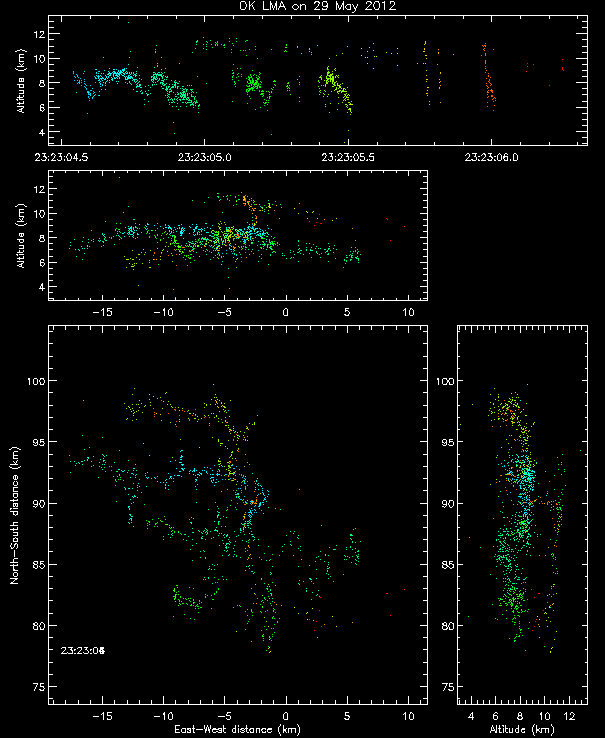
A single, typical flash
A single flash such as the one here is a collection of VHF sources that map its intra-cloud structure. These VHF sources from each lightning flash are clustered closely in space and time and trace out the branching geometry of the lightning channel. All points, colored by time, are included in each panel, so there are multiple projections of the same data. Empty squares or diamonds on the top-down images are the locations of the currently-operating OKLMA stations.
Multiple flashes
Rarely does just a single flash occur. For example, see an animation of several flashes which occurred in only 6 seconds here. The figures on this webpage show all VHF sources associated with however many flashes occurred in set time periods. The VHF source points are still colored by time, but the details of single flashes are less likely to be seen in the longer time periods.
In some cases, individual flashes can still be identified as a group of VHF sources of the same color in one area. For example, the sprawling flashes here near the Texas-Oklahoma border like the one shown in deep yellow points were associated with the production of a sprite! Vertically-stacked points in the upper altitude time series also show individual flashes (if they can be identified). These stacks can give you a rough idea as to whether flash rates are charging with time.
The density images can be helpful for understanding how much lighting activity is happening in any area. They show the 2-D histograms of the same points. One common feature of strong thunderstorms is to find an area near the updraft with fewer lightning channels than its surroundings. This has been called a lightning hole or a weak lightning region. It is the electrical equivalent of a bounded weak region radar signature.
Another common feature in LMA data is known as an updraft pulse or surge signature. These can be identified as a rising plume of sources, at relatively high altitudes, in the upper altitude-time series panel (example). These may terminate in solitary VHF sources within the overshooting top of the thunderstorm.
Other features and data artifacts
Occasionally, we can observe aircraft tracks with the LMA. VHF emissions can occur when aircraft fly through cirrus or other ice-containing clouds. These can be identified as continuous lines of sources, often at constant attitudes and displaced from lightning signatures in the storms themselves. In this case, the aircraft track is just above 10 km, moving to the east-southeast from the central Oklahoma station cluster.
There can also be VHF emissions captured by the LMA from wind turbines. These are generated when there’s a strong electric field, and only observable near the LMA sensors. These can be identified as frequent, near ground emissions from consistent locations. These are relatively common west of the Oklahoma City metropolitan area, such as in this example.
There are artifacts which mean that not every point shown on the map is part of a lightning channel or even a well-located VHF emission. A local VHF source such as a generator, an error in timing by the sensors, or a mismatch in the pulses which are used to solve the time of arrival equations, can result in non-physical solutions. These appear as “noise” in the figures. They are normally not clustered in space or time, and may be at unrealistic altitudes. Often these solutions are along radials from a cluster of sensors towards and beyond the actual thunderstorm. Changes in processing methodology or additional quality control metrics imposed on the post-processed data can reduce the non-physical solutions (see this example where a processing change reduced the artifacts in the later, warm-colored time period from the earlier, cool-colored solutions). Strict filtering is generally kept to a minimum for real time sensitivity.
Contact lightning@ou.edu for more information.